
 The
Island of Montserrat is one of the leeward islands in the Eastern Caribbean.
The latitude and longitude is 17 degrees north and 62 degrees west. The
two extinct volcanoes are Silver Hills to the north, and Katy Hills which
is located in the centre of the island. Almost all of the southern half
of the island has been evacuated to the northern parts of the island. The City of Plymouth has been evacuated sinse April of 1996.
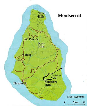
The
Island of Montserrat is one of the leeward islands in the Eastern Caribbean.
The latitude and longitude is 17 degrees north and 62 degrees west. The
two extinct volcanoes are Silver Hills to the north, and Katy Hills which
is located in the centre of the island. Almost all of the southern half
of the island has been evacuated to the northern parts of the island. The City of Plymouth has been evacuated sinse April of 1996.
The two extinct volcanoes have provided a type of shield from the recent erruptions on the northern side of the island, so the majority of evacuees who haven't left the island have located there. Soufriere Hills is the present site of activity and has overgrown the old crator named Chances Peak.
The site of dome growth has been outlined on this map, as well as the path traveled by the September 17th, 1996 eruption, down Tar River Valley.
Due to the trade winds, which generally blow east to west, most of the airborne material is deposited on the West side of the island. Hence the city of Plymouth is constantly being inundated with new ash.
